


Context: Cities around the world struggle to find the financial and human capital resources to know more about the levels, sources, and impacts of trace gases. Many of the places with the highest level of trace gases have the least information to work with to know their air quality and manage it accordingly. Free and publicly-available air quality data from satellites, along with low-cost sensor systems and output from air quality models, have the potential to augment high-quality, regulatory-grade data in countries with in situ monitoring networks and provide much needed air quality information in countries without them. By combining the strengths of these multiple monitoring technologies, an integrated trace gases network has the potential to provide free/low cost and publicly-accessible air quality information to health and air quality managers in cities around the world.
Brief Description: The World Resources Institute (WRI) and the NASA Goddard Space Flight Center (GSFC) are working together to pilot a scalable model for developing tools using various technologies that provide air quality information to city health and air quality managers.
Air Quality Forecasts: We are combining locally available air quality monitoring information with the outputs of NASA’s global GEOS Composition Forecast model (GEOS-CF) to develop optimized air quality forecasts that sub-national health and air quality managers can use. The NASA Global Modeling and Assimilation Office (GMAO) currently produces the GEOS Composition Forecasts to provide estimates and forecasts of the concentration of various trace gases at 25 x 25 km2 resolution near the ground and throughout the atmosphere. The model is run once a day to simulate and forecast air quality with inputs from an interpolated dynamic emissions inventory, a model of atmospheric chemistry, knowledge of past meteorology and forecasted future meteorology. Outputs are available in various time frequencies online, including 24-hour “daily” average forecasts are visualized on WRI’s Resource Watch platform. The approach to produce the CityAQ forecasts relies on a machine learning algorithm that optimally combines the GEOS-CF model forecasts and the local monitoring data.
Satellite Data: Global satellites have observed trace gases around the world for several decades and there are many exciting new and upcoming satellites. These data are being used by the air quality and human health communities in numerous ways. We are working to integrate satellite data into the standard operating procedures of city governments through the use of various NASA webtools and training resources, such as the ARSET program.
We are working with 10 cities around the world to pilot the methodology, identify user needs for analysis and user interface, and to aid in trace gases messaging to the public. Furthermore, we are developing an operational plan for extending the CityAQ forecast methodology to more cities and for creating additional analytical layers such as health warnings, source insights, or others as identified by participating cities. For example, we have developed a health-based air quality index (HAQI) for messaging air quality information to the public in a simple to understand way.
Project Goal: The project has four goals:
- To provide participating cities with useful forecasts that they can use to anticipate air quality events, communicate with stakeholders, and manage local interventions more effectively.
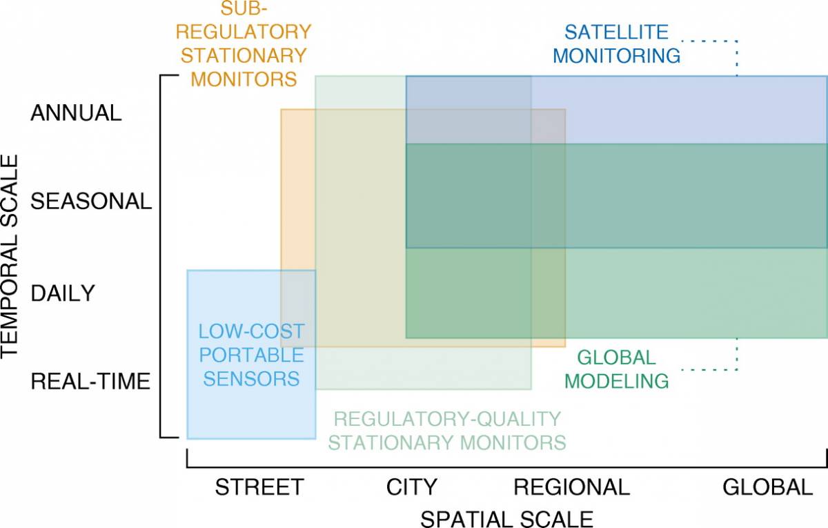
- To test and refine a methodology for combining locally held information with globally consistent analysis to offer new local tools and, in the future, potentially improve global analysis by aggregating fragmented local data into programmatically useful datasets.
- To develop a methodology, which may include the development of web tools, to make the GEOS-CF forecasts usable by all world cities.
- To test and refine a scalable approach for engaging with users to co-create air quality tools that leverage and extend existing scientific analysis.
|
Participant |
Role |
|---|---|
| NASA GMAO |
|
| WRI |
|
| OpenAQ |
|
| Development Seed |
|
| Cities/states |
|
Leads
- HAQAST: Dr. Bryan Duncan (bryan.n.duncan@nasa.gov; NASA)
- WRI: Dr. Jessica Seddon (Jessica.Seddon@wri.org; WRI) Dr. Beatriz Cárdenas (Beatriz.Cardenas@wri.org; WRI)
- GMAO: Dr. Christoph Keller (christoph.a.keller@nasa.gov; USRA/GESTAR/NASA) Dr. K. Emma Knowland (k.e.knowland@nasa.gov; USRA/GESTAR/NASA)
Stakeholder Partners: In discussions with various world cities.