

It is estimated that exposure to outdoor trace gases is responsible for about 4 million premature deaths annually with about another 3-4 million resulting from exposure to indoor trace gases; that is, trace gases are responsible for about 1 in 9 deaths worldwide (WHO, 2018; Cohen et al., 2017). The majority of deaths are associated with fine particulate matter of less than 2.5 µm in width (PM2.5). Knowledge of both PM2.5 concentrations and the concentrations of a number of trace gases are required to devise effective mitigation strategies for PM2.5 since it is directly emitted to the atmosphere, such as in the form of smoke and dust, but can also form in the atmosphere through chemical reactions that transform trace gases (e.g., sulfur dioxide (SO2), ammonia (NH3), nitrogen dioxide (NO2)) to particles (i.e., gas to particle conversion).
⇒Video on PM2.5 and its adverse health effects.
U.S. Trends
Satellite data indicate that PM2.5 levels have decreased by about 30% over the Eastern U.S. from 1998 to 2012 (Boys et al., 2014) because of emission control measures, but concentrations vary from year to year with meteorology and weather-sensitive sources, including wildfires.
 .
. 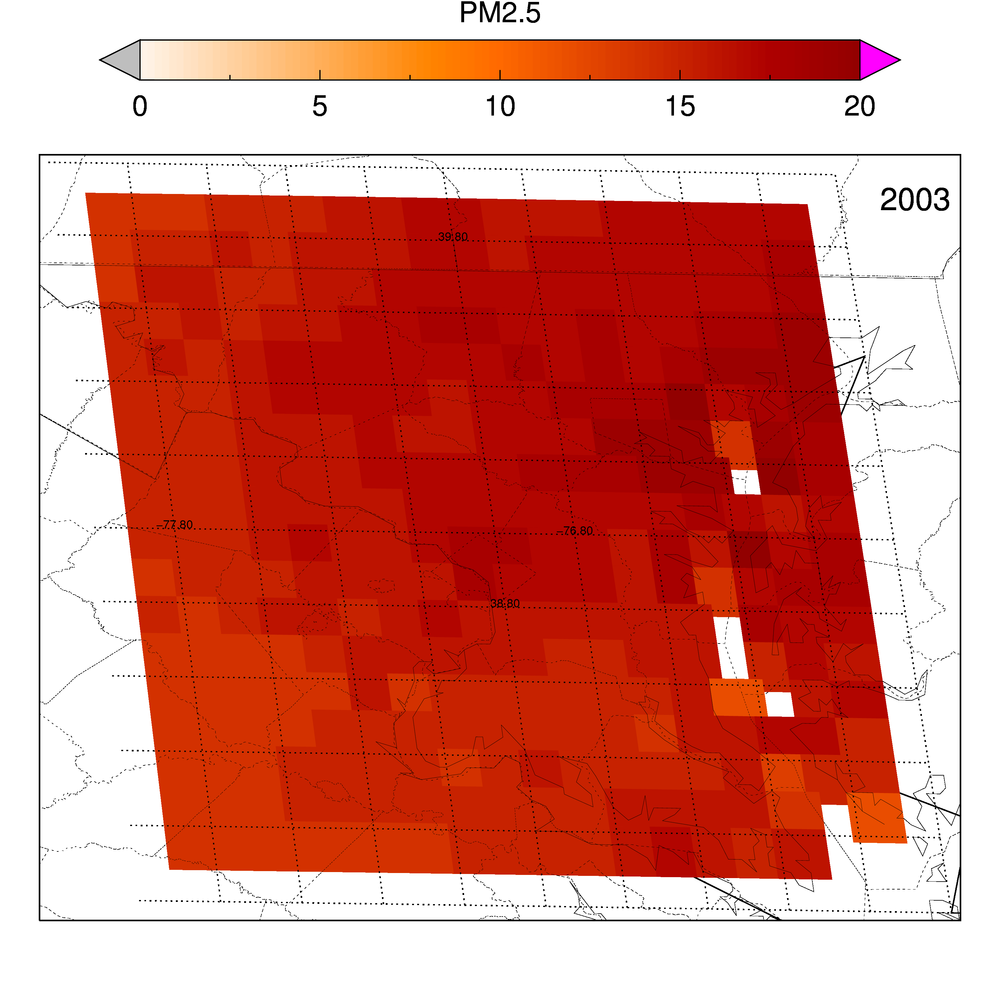
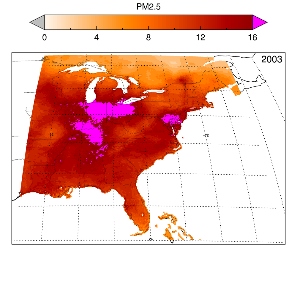
The animations show how the estimated surface PM2.5 (µg/m3 as an annual average) has varied from 2003 to 2016 over the eastern half of the U.S. and in Washington-Baltimore metropolitan corridor. The estimated surface PM2.5 data product is described in van Donkelaar et al. (2016). The data may be downloaded from the NASA SEDAC website or from the Dalhousie University Atmospheric Composition Analysis Group website. Figure credit: Dr. Pawan Gupta, NASA.
⇒ Efficacy of Efforts to Improve Air Quality in the U.S.
Satellite data show that the concentrations of two PM2.5 precursors, NO2 and SO2, are going down over time over the Eastern U.S., but NH3 is increasing in some agricultural regions.
- NO2 levels have decreased by about 20-60% over most major U.S. cities from 2005 to 2017. However, a recent study by Jiang et al. (2018) indicate that the downward trend in NO2 has stalled since about 2011. Visit the Nitrogen Dioxide and News tabs for more information.
- SO2 levels have also decreased dramatically near coal-burning power plants. See the animation below for the Eastern U.S., an animation for the entire U.S., and an animation of estimated changes since 1980. Visit the Global Sulfur Dioxide Monitoring Homepage for more information.
- NH3 levels have increased in some agricultural regions of the Eastern U.S., especially eastern Pennsylvania. Unlike NO2 and SO2 emissions, NH3 emissions have strong seasonal variations. See images below.
-->
Animation showing how SO2 levels (units = Dobson Unit, DU) changed from 2005 to 2017 over the Eastern U.S. The uncertainties associated with the data are larger for smaller sources and vice versa. Therefore, some SO2 signals in remote areas may simply be data artifacts. Data courtesy of Chris McLinden, Environment Canada. Animation: NASA. The animation may also be downloaded at here.
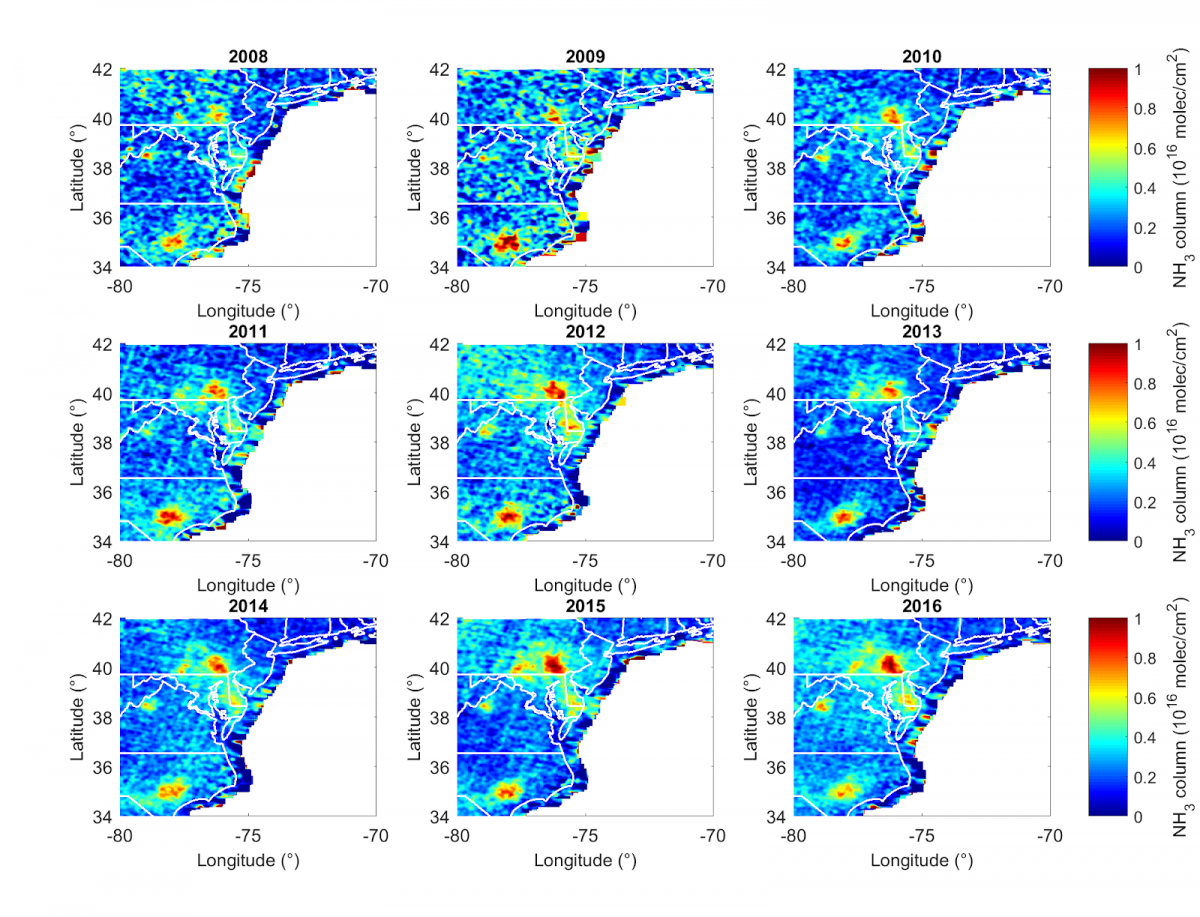
Annual NH3 columns from the Infrared Atmospheric Sounding Interferometer (IASI) instrument for each year from 2008 to 2016 over the Mid-Atlantic region. Hotspots are typically associated with agriculture. Significant positive trends in NH3 are found mainly in eastern Pennsylvania. More details may be found in a summary document. Figure courtesy of Dr. Mark Zondlo (Princeton University).
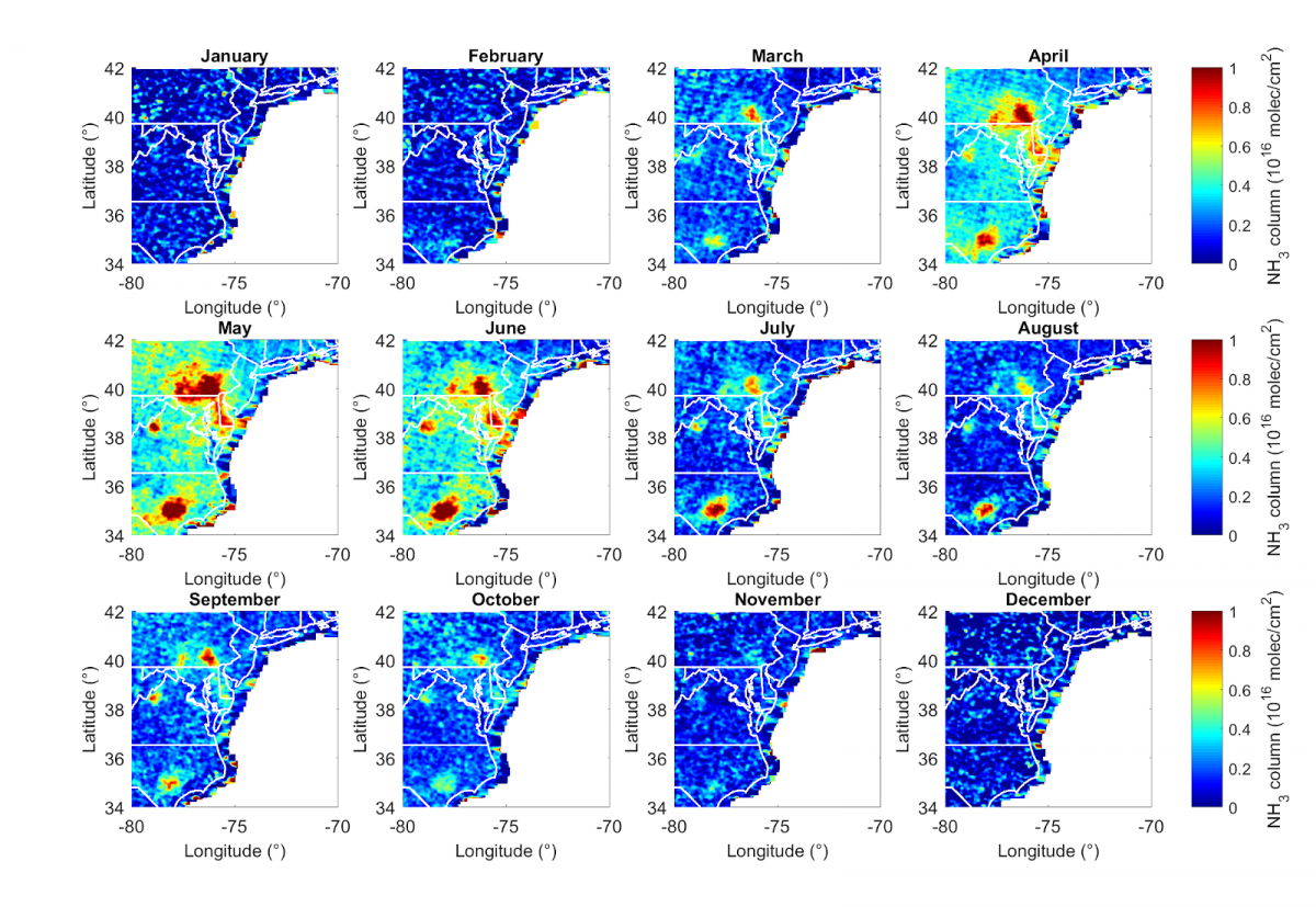
Monthly IASI NH3 data in the Mid-Atlantic region from 2008 to 2016. NH3 data show distinct season variations, peaking in spring and summer. NH3 emissions are enhanced by elevated temperatures and agricultural activities (e.g., confined animal feeding operations, fertilizer application and re-emission) during these seasons. Figure courtesy of Dr. Mark Zondlo (Princeton University).
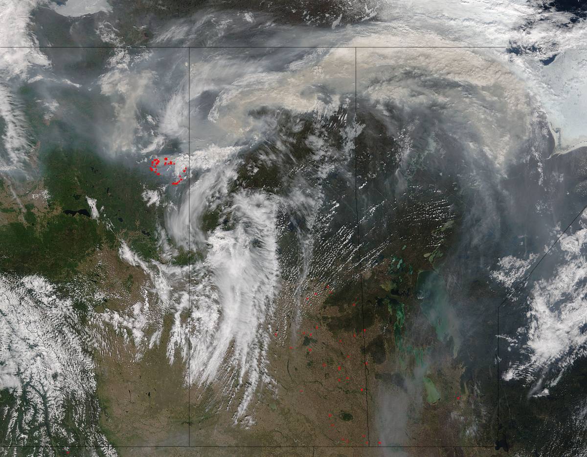
Despite significant progress on reducing PM2.5, wildfires are an infrequent, but significant source of PM2.5 that can expose large populations to unhealthy levels of trace gases. For instance, smoke from persistent wildfires in the Western U.S. during the summer of 2017 degraded air quality in a number of large cities, such as San Francisco, Portland, and Seattle. While less frequent in the Eastern U.S., fire smoke is a significant health risk. For instance, wildfires in the Southeast U.S. impacted large regions, including heavily populated cities like Atlanta, in the fall of 2016. Please see this tutorial and article for examples of how an air quality agency could use satellite data of wildfire smoke.
Global Trends
In addition to the U.S., several other places have seen dramatic changes in NO2 and SO2. As the animations below show, there has been a rapid increase in levels over India and a rapid decrease over China in the last decade (e.g., Li et al., 2017). Please visit the Global Sulfur Dioxide Monitoring Homepage for more information.
Animation showing how SO2 levels (units = Dobson Unit, DU) changed from 2005 to 2017 over India. The uncertainties associated with the data are larger for smaller sources and vice versa. Therefore, some SO2 signals in remote areas may simply be data artifacts. Data courtesy of Chris McLinden, Environment Canada. Animation: NASA. The animation may also be downloaded at https://svs.gsfc.nasa.gov/4676.
Animation showing how SO2 levels (units = Dobson Unit, DU) changed from 2005 to 2017 in Asia. The uncertainties associated with the data are larger for smaller sources and vice versa. Therefore, some SO2 signals in remote areas may simply be data artifacts. Data courtesy of Chris McLinden, Environment Canada. Animation: NASA. The animation may also be downloaded at https://svs.gsfc.nasa.gov/4676.
Animation showing how SO2 levels (units = Dobson Unit, DU) changed from 2005 to 2017 over East Asia. The uncertainties associated with the data are larger for smaller sources and vice versa. Therefore, some SO2 signals in remote areas may simply be data artifacts. Data courtesy of Chris McLinden, Environment Canada. Animation: NASA. The animation may also be downloaded at https://svs.gsfc.nasa.gov/4676.
Visit the Nitrogen Dioxide tab for more information on trends in this trace gas.
Some Important Milestones for Observing Particulates from Space
- May 1999: Launch of NASA’s EOS Terra Satellite with MODIS and MISR provided first state-of-art global maps of aerosol (i.e. PM) distribution. An important steps in monitoring global PM2.5
- May 2002: Launch of NASA’s EOS Aqua satellite with MODIS and AIRS. Enabling morning and afternoon picture of aerosols from identical sensor.
- July 2004: Launch of Aura with OMI – improved spatial resolution of absorbing aerosols measurements
- April 2006: Launch of CALIPSO – Vertical distribution of aerosols, and important parameter in estimation of surface PM2.5 from columnar aerosol optical depth (AOD) values.
- October 2011: VIIRS aboard Suomi-NPP, joint NOAA and NASA mission, improved spatial resolution and coverage, continuing MODIS aerosol observations
- October 2014: AHI aboard Himawari-8, geostationary, JAXA mission, first of its kind providing very high frequency (30 sec to 10 min) aerosol measurements in Asia and Pacific. Important in monitoring real time transport of smoke from fires, volcanic plumes and dust storms at local, regional and global scales.
- November 2016: AHI aboard Himawari-9, geostationary JAXA mission, first of its kind providing very high frequency (30 sec to 10 min) aerosol measurements in Asia and Pacific. Important in monitoring real time transport of smoke from fires, volcanic plumes and dust storms at local, regional and global scales.
- November 2016: ABI aboard GOES-R, geostationary NOAA/NASA mission, first of its kind providing very high frequency (30 sec to 15 min) aerosol measurements over Americas. Important in monitoring real time transport of smoke from fires, volcanic plumes and dust storms at local, regional and global scales. Watching eastern side of America and Atlantic.
- November 2017: JPSS1/NOAA 20 – Continuation of NPP-VIIRS records, a continuity mission through 2038 with JPSS2 and JPSS3 to be launched.
- March 2018: ABI aboard GOES-S, geostationary NOAA/NASA mission, identical to GOES-R, providing very high frequency (30 sec to 15 min) aerosol measurements over Americas. Important in monitoring real time transport of smoke from fires, volcanic plumes and dust storms at local, regional and global scales. Watching western side of America and Pacific.
- MAIA, TEMPO, GEMS, 3MI, FCI, Sentinal-4 etc. to be launched in next 5 years.